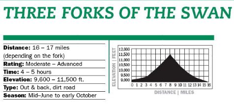
Know Before You Go: Expect vehicle traffic on Tiger Road and some jeeps in the upper drainages. Private property (including many fragile mining structures) is common in the area. Respect all “No Trespassing” signs and view historic buildings from a distance.
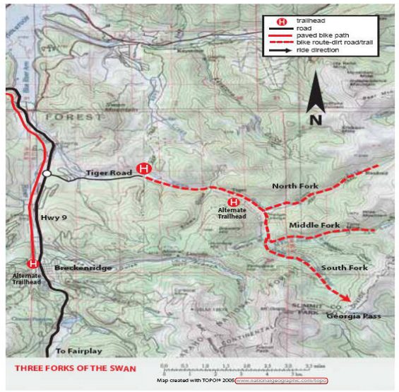
Parking: From Hwy 9 turn right onto Tiger Road ( by the Breckenridge Golf Course) and drive 2.6 miles. Park in the small parking area near a pond containing a historic dredge boat). [/box]
North Fork Description:
Follow the directions to Tiger Rd. Follow Tiger Road to the junction at 3.2 Miles, turn left on the North Fork Road. Ride along the left side of the meadow, through a gate and into the trees. A short distance further, turn (left) onto a side road where the main road curves right and crosses the river. Begin climbing more steeply over sometimes rocky terrain. Connect with the main road again after a about a mile and continue up the left side of the drainage. Continue straight past a gated spur on the left. The road narrows, climbs several short, steep pitches through dense forest and reaches some dilapidated cabins in a small opening at about 5.5 miles. Continue climbing, now over more challenging terrain. As you near timberline the valley widens, mountains appear and collapsed buildings marking the old Rexford townsite dot the hillside. Climb over rocky terrain into a spectacular high alpine cirque. Turn around at the 3-way junction near a stream. Both spurs dead-end shortly beyond this point.
South Fork Description: Follow the directions to Tiger Road. At the junction at 3.2 miles, stay right toward the South/Middle Forks. Pass some private property and at the next junction, turn right and cross the river. At about 4.7 miles, reach a major 4-way junction near mining remains. Turn left, cross the river and climb more steeply along the left side of the drainage. Beyond a house the road become quite rocking as it passes some spurs on both the left and right. Ford the river at almost 6.7 miles and take either fork (they connect again shortly) up the first of many steep, technical pitches. Beyond a gate, pass two spurs on the right, then turn sharply left and drop into the meadow. More steep climbs that may require walking bring you to Georgia Pass for a well-deserved rest. Roads head in all directions – some dead-end, another accessed the Colorado Trail and also traverses along the Glacier Peak to connect with the Middle Fork Road, and the main road heads down to Jefferson and Hwy 285. Return as you came.
Middle Fork Description: Follow the directions to Tiger Road. At the junction at 3.2 miles, stay right toward the South/Middle Forks. Pass some private property and at the next junction continue straight, following the Middle Fork Road up the left side of the drainage. the road veers left and passes through a gate. Climb gradually through the forest, passing several side roads. Pedal up some short steep pitches separated by level recovery areas. Beyond a spur on the right in an open hillside, at about 7.5 miles, the road gets steeper and more technical. It switchbacks upward past the remaining buildings of Swandyke. Climb into a beautiful mountain meadow. Pass a spur on the left and continue up the main road to a well-preserved building perched on a steep slope. Beyond this point, the road ascends steeply and connects with routes which drop into Montezuma. Expect to walk a lot if you continue. From the historic building, it is recommended to return as you came.
Map & Information courtesy of Summit Daily, 2013 Bike Guide